GPR Cost Versus Level of Confidence
GPR Cost Versus Level of Confidence
When it comes to concrete scanning using ground penetrating radar (GPR), the cost, level of effort, and degree of confidence are closely interconnected. Understanding how these factors influence each other is essential for making informed decisions about GPR services.
Concrete Scanning Costs and Decision Factors
Cost is often the primary deciding factor when selecting a GPR concrete scanning service. Availability is typically the second most important consideration. However, these criteria don’t always reflect the quality of the work provided.
Many contractors, project managers, and engineers assume that all GPR services are equal, but this is far from the truth. The level of effort and the degree of confidence in the results can vary significantly between providers. Unfortunately, clients may not fully understand the technology or the limitations of GPR, leading to unrealistic expectations.
If an accident occurs—such as hitting an unmarked utility line—the blame often falls on the concrete scanner. While it’s true that no GPR service can guarantee 100% accuracy (since results are based on indirect observations), this should not be the standard operating mindset. Instead, clients should understand the level of service they are receiving and how it impacts the confidence of the results.
Balancing Cost, Effort, and Confidence
When budgets or time are limited, it’s important to strike a balance between cost and the level of effort required to achieve the desired degree of confidence. GPR services can be tailored to meet specific client needs, but it’s crucial to understand that higher confidence levels generally require greater effort and certainly post processing.
Follow these leads…..

It is quite possible to work without results, but never will there be results without work. Unknown Author
Factors That Increase Confidence in GPR Results
Achieving a higher degree of confidence in GPR results often involves additional steps and considerations. Below are some key factors that contribute to more reliable and accurate concrete scanning outcomes:
1. Continuity
Mapping a feature from one known location to another is critical for ensuring accurate results. For example, if you’re locating a compressed air line in a hospital, it’s not enough to scan a single area. You need to map the line continuously to confirm its path and ensure it doesn’t intersect with the area where concrete will be cut.
- Example: A compressed air line feeding a hospital surgery room must be mapped to avoid accidental damage. Scanning only a small area near the cut zone may miss critical details, leading to costly mistakes.
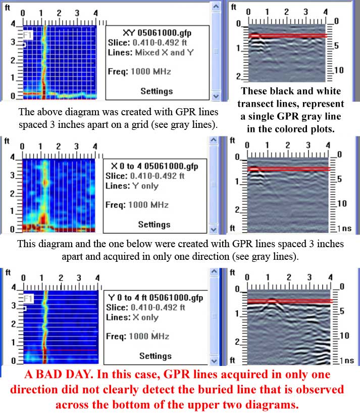
2. Resolution
The spacing of GPR scan lines significantly impacts the resolution of the results. Closely spaced lines (3 inches or less) provide higher resolution and more detailed imaging, while wider spacing (3 to 12 inches) may miss smaller features.
- Example: A multi-line survey with closely spaced perpendicular lines can reveal detailed information about rebar, conduits, or voids. In contrast, a single scan line may fail to detect a water line running perpendicular to the scan direction.
3. Mapping vs. Detection
To fully understand the features within a concrete slab, it’s often necessary to collect GPR data in a grid pattern, with lines running perpendicular to each other. This approach provides a more comprehensive view of the area and reduces the likelihood of missing critical features.
- Example: A grid survey is often far better at mapping the location and orientation of rebar, post-tension cables, or utility lines, ensuring safer drilling or cutting.
4. Spatial Control and Marking
Permanently marking spatial control points is essential for relocating and reorienting the GPR results on-site. Without these reference points, it can be difficult to apply the scan data accurately to the area of concern.
- Example: A contractor scans a concrete slab and marks key points on the surface to ensure the GPR results align with the actual site conditions during construction.
5. Test Survey Areas
Conducting a test survey over a known area can help verify the accuracy and functionality of the GPR equipment. This quality assurance step confirms that the equipment is working correctly and provides a baseline for interpreting results.
- Example: A test survey at the start and end of the day can identify equipment malfunctions and ensure consistent results across the project.
6. Post-Processing and Analysis
While GPR equipment often provides real-time results, post-processing the data can significantly improve the quality and accuracy of the images. Taking the time to analyze the data in detail allows for better interpretations and more reliable conclusions.
- Example: An operator reviews the GPR data off-site, using advanced software to enhance the resolution and identify features that may not have been visible during the initial scan.
The Risks of Minimal GPR Services
A minimalistic approach to GPR scanning—such as scanning a single unrecorded line without marking reference points—may save money upfront but often leads to lower confidence and higher risks.
- Example: A contractor using a single scan line to locate a utility line may miss nearby features, resulting in accidental damage during cutting or drilling.
While this approach can be useful for relocating a known feature just before cutting, it is not a cost-effective solution for comprehensive investigations. The potential repair costs from hitting an unexpected or unidentified target far outweigh the initial savings.
What to Expect from a GPR Survey
It’s important to understand that GPR provides indirect observations of features at depth. Unlike intrusive methods, which yield direct observations, GPR relies on detecting and mapping electromagnetic fields reflected from subsurface targets.
Limitations:
- GPR cannot directly identify the exact nature of a feature (e.g., whether a target is a pipe, conduit, or void).
- The accuracy of the results depends on factors such as target size, depth, reflectivity, and the dielectric properties of the materials.
Key Considerations:
- Anomalies detected in the GPR record must be validated through other means, such as direct observation or additional testing.
- Conclusions drawn from GPR data should not be misconstrued as absolute facts but rather as informed interpretations.
Balancing Cost and Confidence: A Practical Approach
When requesting GPR services, clients should consider their specific needs and the level of confidence required for the project. For critical applications, such as locating utilities in high-risk areas, investing in higher-resolution scans and comprehensive mapping services is, more or less, essential. For less critical tasks, a more basic approach may suffice.
Conclusion
The cost of GPR concrete scanning is directly tied to the level of effort and degree of confidence in the results. While minimal services may save money upfront, they often come with higher risks and lower reliability. By understanding the factors that influence GPR accuracy—such as continuity, resolution, and post-processing—clients can make informed decisions that balance cost and confidence.
Whether you’re a contractor, engineer, or project manager, investing in quality GPR services can help you avoid costly mistakes, ensure safety, and achieve better outcomes for your project.
Review of Validation of NDT Equipment for Concrete
Review for GPR on the Validation of NDT Equipment for Concrete This document concluded Ground Penetrating Radar (GPR) : The ...